


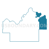
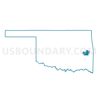
Voting District 31, Haskell County, Oklahoma
About
Outline

Summary
| Unique Area Identifier | 654116 |
| Name | Voting District 31 |
| County | Haskell County |
| State | Oklahoma |
| Area (square miles) | 75.30 |
| Land Area (square miles) | 50.98 |
| Water Area (square miles) | 24.32 |
| % of Land Area | 67.70 |
| % of Water Area | 32.30 |
| Latitude of the Internal Point | 35.28775360 |
| Longtitude of the Internal Point | -94.88391110 |
Maps

Graphs
Select a template below for downloading or customizing gragh for Voting District 31, Haskell County, Oklahoma


Neighbors
Neighoring Voting District (by Name) Neighboring Voting District on the Map
- Voting District 101, Le Flore County, OK
- Voting District 11, Haskell County, OK
- Voting District 112, Le Flore County, OK
- Voting District 15, Haskell County, OK
- Voting District 203, Sequoyah County, OK
- Voting District 204, Sequoyah County, OK
- Voting District 304, Sequoyah County, OK
- Voting District 4, Haskell County, OK
Top 10 Neighboring County Subdivision (by Population) Neighboring County Subdivision on the Map
- Muldrow CCD, Sequoyah County, OK (10,626)
- Vian CCD, Sequoyah County, OK (8,077)
- Spiro CCD, Le Flore County, OK (7,577)
- Panama-Bokoshe CCD, Le Flore County, OK (6,116)
- Stigler CCD, Haskell County, OK (4,293)
- Keota CCD, Haskell County, OK (2,108)
Top 10 Neighboring Place (by Population) Neighboring Place on the Map
Top 10 Neighboring Unified School District (by Population) Neighboring Unified School District on the Map
- Sallisaw Public Schools, OK (12,287)
- Stigler Public Schools, OK (6,628)
- Vian Public Schools, OK (4,716)
- Keota Public Schools, OK (2,708)
- Gans Public Schools, OK (1,646)
- Bokoshe Public Schools, OK (1,433)
- McCurtain Public Schools, OK (1,098)
Top 10 Neighboring State Legislative District Lower Chamber (by Population) Neighboring State Legislative District Lower Chamber on the Map
Top 10 Neighboring State Legislative District Upper Chamber (by Population) Neighboring State Legislative District Upper Chamber on the Map
Top 10 Neighboring 111th Congressional District (by Population) Neighboring 111th Congressional District on the Map
Top 10 Neighboring Census Tract (by Population) Neighboring Census Tract on the Map
- Census Tract 403.01, Le Flore County, OK (6,116)
- Census Tract 302.02, Sequoyah County, OK (5,509)
- Census Tract 2792, Haskell County, OK (4,293)
- Census Tract 304.01, Sequoyah County, OK (4,009)
- Census Tract 402.99, Le Flore County, OK (3,734)
- Census Tract 2791, Haskell County, OK (2,108)
Top 10 Neighboring 5-Digit ZIP Code Tabulation Area (by Population) Neighboring 5-Digit ZIP Code Tabulation Area on the Map
- 74955, OK (15,344)
- 74462, OK (7,875)
- 74962, OK (5,092)
- 74941, OK (2,713)
- 74930, OK (2,155)
- 74944, OK (1,272)